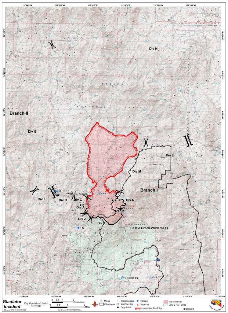
(Update 7:06pm: Below is now the official high-res map of the day)
We got a copy of the latest fire map. This is not the topo map, we are still trying to get that. This is a map that shows the roads. The fire is getting so large, that I don’t know if we will be able to get a good copy of it, but we will try. You can see clearly on this map how much growth has been attained by the Gladiator Fire as it is growing North away from the town of Crown King. Seven Air Tankers (Slurry Bombers) are currently making passes at the fire and are trying to accomplish as much as possible before high winds ground them early this afternoon. They are hoping to continue making passes until 2pm today.
Check back often for more updates on the Gladiator Fire and updates as to what is happening in Crown King.


They just updated this map.
http://www.inciweb.org/incident/2864/
So sorry to see this. I grew up in Crown King in the 60’s and went to school there, my dad had mining claims north of town, all scorched earth now. 🙁
That is where this map came from. Do you remember which claims your dad owned?
Ah yes, I see the map first posted here, down on that page as well. The google map is handy for zooming in and out on the terrain.
My dad had claims north of the Lincoln mine. I spent many hours exploring and hiking there when I was a kid.
We knew the VanTilborgs, in fact one year at the school house there were only 4 students, me, my two brothers and Ritchie VanTilborg.
Like my sister said, the claims were north of the Lincoln group of patented claims. They were called the Bluebird, Pelican and Parrot claims and were all on old mines to the east and northeast of the Gladiator mine.
My dad, Morse Whitley, began building his beautiful little cabin on Tower Mountain Road in the early 1970s, and lived there for nearly 20 years. His little piece of land had belonged to the VanTilborgs, one of the earliest families in Crown King. Dad had loved the area since he was a boy in the 1930s. My heart goes out to everyone concerned, especially Jim who bought Dad’s place. Blessings on the fire crews.
I own the ZIKA claim. Does anybody know if that area is burned?
I am currently uploading a video of a google earth tour with the fire map overlay and actually talked about the Zika. The house right at the entrance to the mine (don’t want to use his name, but I am sure you know who I am talking about) is still standing but all the land to the east and north is burned. Looks like the fire burned to your gate and burned the canyon North of you. I don’t know your exact boundaries, but the fire has not burned the mine entrance area. Hope that helps, and check back in an hour or so for the new post with the video to see what I am talking about.
We are on the Summit Claim (between Gladiator/Del Pasco) and according to the map it looks like the fire was stopped right at our doorstep as well. Can’t express enough how grateful we are to see this.
I am soo glad you are posting the map!!! Still praying and loving on all of you!!
The Crown King community is in my thoughts and prayers, it is definitely my favorite place on earth and I hope for the best!
Thanks for all the updated info. I have a cabin in Pine Flat which is just north of Crown King. Any idea how close it is to that area now? Debbie
I am just so horrified how quickly this fire spread. Since fire is SO devastating,
why aren’t there huge swaths of Fire Lanes, to prevent the fire “jumping?”
The forest will re-grow, but my concern is future fires that have no “boundaries”
on them…
My thoughts an prays are out to all the people in crown town I swear that Place left such a tattoo on my heart, love everyone up there an hope everything goes well. Sara wimmer